
Virtual Orienteering-
Maps
VO Records
Instructions
Virtual Orienteering
uses Street View to 'walk' around an area finding the answer to 20 clues shown
by symbols on a map. Anyone can do it. You do not have to join
Knox SOW. Just
go to our Maps webpage, choose where you would like to 'walk', print a Map
Sheet, click on the Start/Finish Location link to open Maps at that location,
change to Street View and away you go!
Here’s how –
| 1. |
Go to the
Maps
or
VO Records webpages and select an area to ‘walk’.
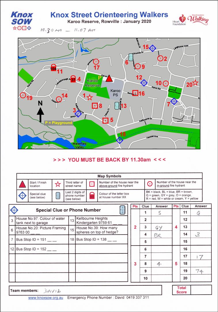
Click or tap on the Month to open the Map Sheet.
Print it out. Note that some areas may have 2 courses. |
 |
|
| 2. |
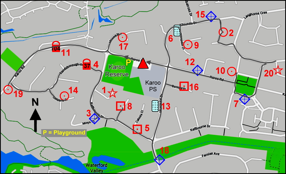
Look for the Red Triangle that is at the Start/Finish Location. |
  |
|
| 3. |
Choose a route around the streets from the Red Triangle so you visit the
location of each clue.
Drawing a line from the Start/Finish Location to each clue in sequence
may help. You must finish
back at the Start/Finish Location. Note that the clues are numbered in red. This number relates to the points scored for finding the correct answer to the clue. It is not the sequence in which you visit each clue. |
| 4. |
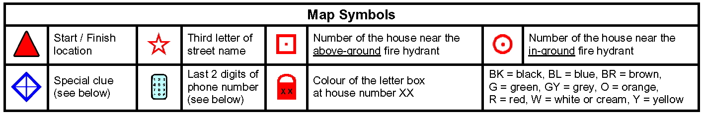
Refer to the table below the map to discover what each symbol
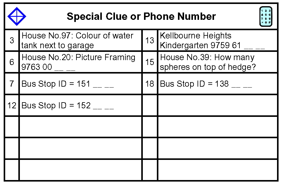
represents. Note that the
Special Clues (Blue Diamond or Phone Number) are written in the table at
the bottom left of the Map Sheet. |
  |
|
| 5. |
Go to the
Maps
or
VO Records webpages and click
or tap on the Start/Finish Location link to automatically open Google Maps at this location. (Alternatively open a separate program or app such as Google Earth, Maps, etc. that has a ‘Street View’ function and enter the address from the top of the Map Sheet into the Search box. |
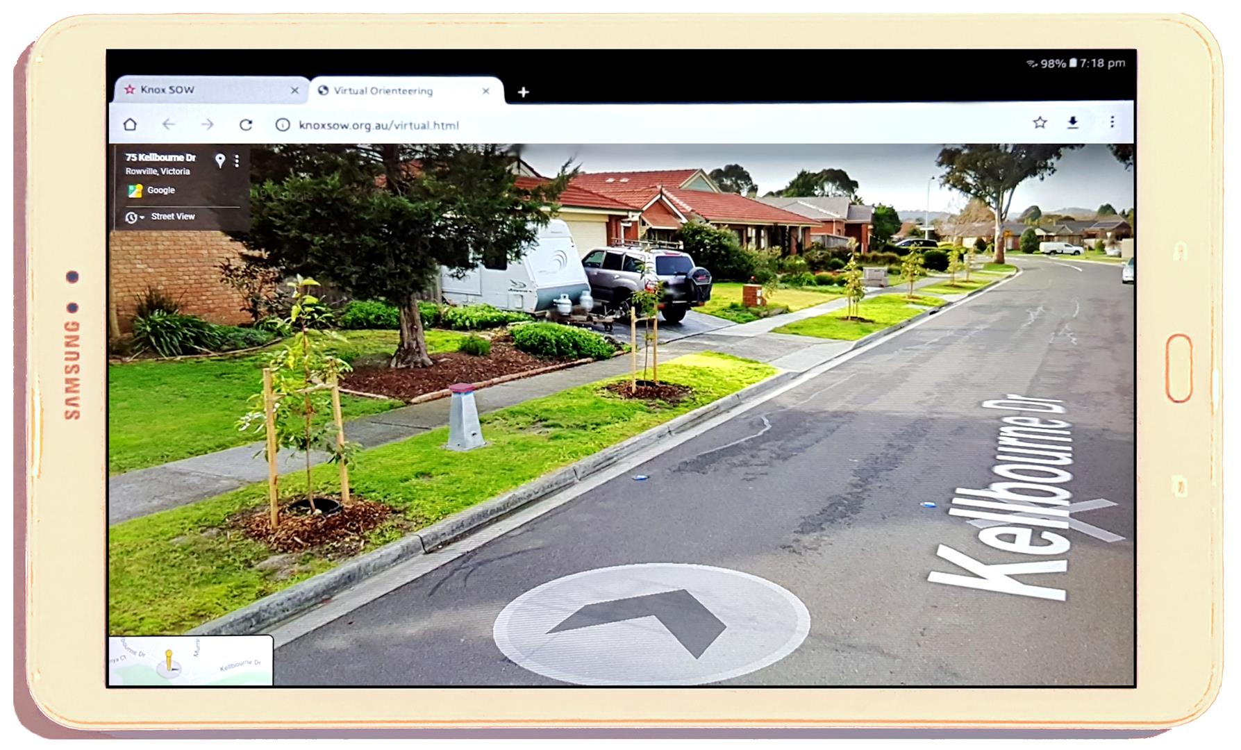
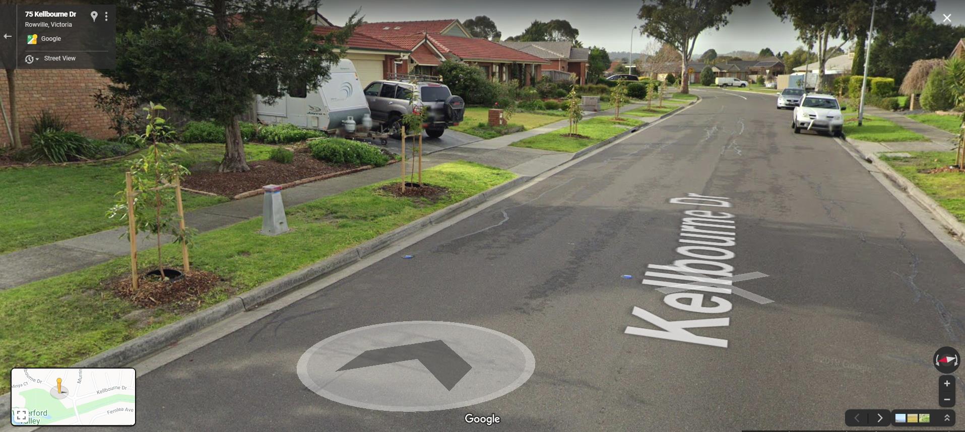
| 6. | Click
or tap on the Start/Finish Location so you get the Street View image Different programs or apps have different ways to go to Street View. You may have to first click or tap the little yellow man or a small window containing an image of the street view. Some apps have a 'What's Here ?' link. |
| 7. | Write
the time you start on the top of the Map Sheet. |
 |
|
| 8. |
Move the image around the streets from clue to clue in the route
sequence you drew in Step 3 and find the answers. Note that you may have to miss some clues as they may not be visible from the road or they may have disappeared or changed. Please make a note of these so they can be noted on the VO Records page and the Master Maps updated. |
 |
|
| Clue
5
(Hint:
Fire Hydrants are often indicated by a blue reflector in the road.) |
|
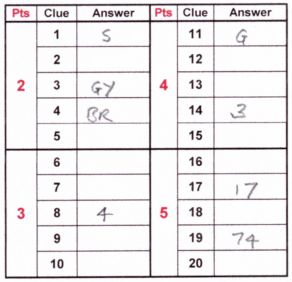
| 9. | Write the
answers in the table at the bottom right of the Map Sheet. |
 |
|
| 10. |
When you have been to all 20 clues find your way back to the
Start/Finish Location and write down your finish time. |
 |
|
|
Well done!
You have just completed a
Virtual Orienteering
course! Check out the VO Records to see if you are a VO Record Holder. |
|
| 11. |
Send a copy of your Map Sheet and the time it took you to complete the
course, to the Walk Organiser, David, for checking your answers.
Let him know if there were any problem clues. (Send a photo or scan by text, WhatsApp or email. 0419 337 311 david@knoxsow.fun ) |
| 12. |
If you want to compete against someone else in your household, print out
another Map Sheet and see if they can beat your time and get all the
answers correct. |
| V3 : Feb 2021 |
|